A platform for plenty of data
Different people have different preferences on how to take in information. Some prefer text, others like a graph or a table, and many of us want to put information on amap! Through the use of GIS- based, layered information and data tagged with GPS position, the user can visualise all data available in the MIDAS system on a map. Themap used is typically a Google Map that enables it to be zoomed, panned and view in a map- or satellite mode. The presented information is customised through timeperspective (historic, present and future) and the selection of information is divided into various layer(s), for example presentation of data from mobile units duringmeasuring, vehicles moving on the runway, selection of data from fixed sensors, alarms etc. It is all down to how you as a user want to have the information presented!
MIDAS is web-based and can be accessed and viewed through any internet-connected computer or device through a secure login. The user-interface is responsive and platform-independent and can thus be viewed on a regular desktop, laptop, workstation or a tablet, like for instance an iPad.
Through MIDAS, data can be viewed in realtime OR retrospectively, providing a tool to look at all current conditions as well as an archive for historic measurements with all corresponding data and images to further illustrate.
It is said that those who do not learn from history are bound to repeat it. MIDAS can present historical data collected by the system in graphs, tables and in map-view as well as corresponding images. When historic data is presented from one data source, data from other sources for the corresponding timeperiod can be presented side by side. If there has been an event or incident, what was the available information at that point in time? What decisions could have been made different? A friction measurement has been performed with poor friction values detected. What other conditions can explain the poor friction values? De-icing was distributed on the runway, how long did the effects last? What other conditions impacted the effects? Questions like these can be answered by studying what happened in the past. Ultimately knowing your history enables a better understanding of your runway and a more informed decision making in the future. When you're done studying the past, simply click the "Go-Live” button and your back displaying live data and images!
Choose a specific date and time or choose a historic measurement and view all the rest of the collected data form that corresponding time and location.
Within MIDAS you have a very sophisticated, yet easy to set-up Rules and alert system. You simply chose any condition that you which to trigger an alert, or a combination of conditions and then set the desired thresholds if applicable (for example if runway temperature is below freezing (threshold=0°C) or if you have ice on the runway). You can even chose a combination of conditions, like strong wind in combination with precipitation in form of snow.
The alerts can be set up to trigger one of 3 different alert-levels:
![]() If no rule is violated the sensor and station is green
If no rule is violated the sensor and station is green
![]() This lowest alert-level can be used to indicate something not dangerous but worth observing. The sensor and station becomes yellow.
This lowest alert-level can be used to indicate something not dangerous but worth observing. The sensor and station becomes yellow.
![]() This medium alert-level can be used to highlight a condition of increasingly importance, for instance trending towards a possibly dangerous condition. The sensor and station becomes orange.
This medium alert-level can be used to highlight a condition of increasingly importance, for instance trending towards a possibly dangerous condition. The sensor and station becomes orange.
![]() The highest alert-level. The sensor and station becomes red. This can be used to alert of a dangerous condition such as presence of ice on runway, flooding etc.
The highest alert-level. The sensor and station becomes red. This can be used to alert of a dangerous condition such as presence of ice on runway, flooding etc.
Together with each individual rule, an action can also be applied if the alert is triggered, such an action can be to send a text-message and/or an e-mail to a specific individual or a group of persons. Each rule is individually set up so a notification can be sent to the relevant individual for any specific occasion. This means you do not need to observe the system at all time but correctly set up the system contacts you if there is issues to tend to or observe.
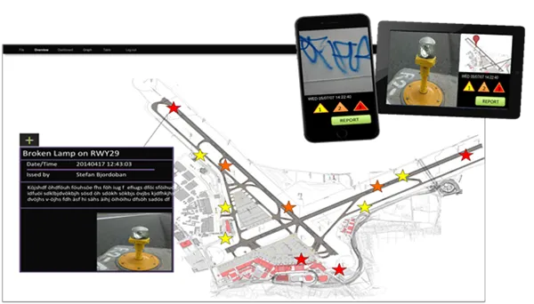
Say that you are on the runway doing a measurement while passing a broken lamp or something else worth reporting and documenting, maybe a crack in the pavement. You pick up your smart phone or your tablet and start the MIDAS ER app (Event Reporting app). The app starts the camera and you take a picture, select severity level, adjust the position in the map if needed and write a short comment. You then click send and the event is logged within MIDAS. The event is then visible in both the mapview and within the app itself. If you have manager-rights you can assign the event as a task to a coworker, change the severity-level, add comments etc. MIDAS event-app can be used to record and manage all types of event and tasks, from a broken light on therunway to graffiti in the parking garage and the app can be downloaded and deployed to as many users as the administrator wishes.
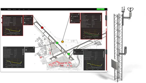 Data from fixed sensors
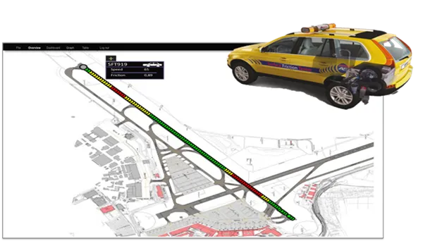 Data from mobile measurements
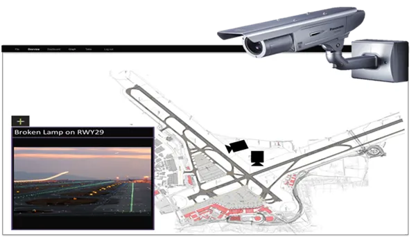 Cameras for liveview and image capture for follow-up
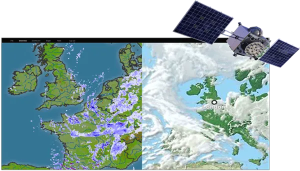 Radar and Satelite
 Event management and reporting
This website uses cookiesfor statistics and user experience.
This website uses cookies to improve your user experience, to provide a basis for improvement and further development of the website and to be able to direct more relevant offers to you.
Feel free to read ours privacy policy. If you agree to our use, choose Accept all. If you want to change your choice afterwards, you will find that option at the bottom of the page.